
[posted reply to wrong threadsorry.]
The Largest Car Forum in the Philippines
- Forums
- Discussions
- Events
- Community
Results 81 to 100 of 758
-

 Tsikot Member Rank 3

- Join Date
- Nov 2005
- Posts
- 750
August 9th, 2007 10:59 AM #81Last edited by ineedmorehp; August 9th, 2007 at 11:01 AM. Reason: 1
-
 Verified Tsikot Member
- Join Date
- Mar 2007
- Posts
- 33
August 9th, 2007 09:44 PM #82Hello guys,
It's only a matter of time when local content and service providers, get involved actively into this space.
With that said, please do answer this sponsored GPS Survey.
http://philgpssurvey.net
This information will help us understand the need of local consumers for such devices.
BTW, you can also win an iPod if you are the first to refer 50 respondents.
Thanks
Duke9631
-
 Tsikot Member Rank 3
- Join Date
- Sep 2005
- Posts
- 1,218
-
 Tsikoteer
- Join Date
- Oct 2002
- Posts
- 29,354
-
 Tsikoteer
- Join Date
- Oct 2002
- Posts
- 9,894
-
Tsikoteer
- Join Date
- Oct 2002
- Posts
- 29,354
August 10th, 2007 08:37 AM #86 Originally Posted by M54 Powered

meron na map for metro manila (at least). Pwede na muna yun, update na lang later yung meron sa ibang areas.
-
Verified Tsikot Member
- Join Date
- Mar 2007
- Posts
- 33
August 10th, 2007 12:04 PM #87Straight Six,
Oo nga e. kaya lang our map/content and even software, although useful for demo. It is still not yet commercial grade. (one way streets, U-turn slots etc..)
Hopefully with the survey we will understand better the needs of potential gps users and know where to focus.
Please do answer the survey and better yet refer your friends.
Regards,
Duke
-
Tsikot Member Rank 2
- Join Date
- Jan 2007
- Posts
- 2,819
August 10th, 2007 12:24 PM #88You'll probably need to update the unit with local maps. Originally Posted by archangel_1911
Almost all GPS navigation units (including those that come standard on cars like BMWS and Benzs) can do stuff like route calculation automatically, the big problem is really getting maps. Hopefully duke's product will take care of that.
*duke,
Is your company planning to sell maps separately? Say if we want to use it with a car's built-in GPS?
-
Verified Tsikot Member
- Join Date
- Mar 2007
- Posts
- 33
August 10th, 2007 03:06 PM #89Hi doc, it all depends on this market research. I have been saying this for a long time (lol) and have gestated this for a while .. We will decide how we will play in this field when analyze the data and validate or debunk some of our assumptions. Market size and sustainability is something we are figuring out. Competition is also a given. Originally Posted by Dr.Kamiya
This is also a function of the strategic partnerships that will be formed in the future.
Regards,
- Duke
-
 kaya ng 2H yan!
- Join Date
- Oct 2002
- Posts
- 1,375
August 10th, 2007 04:10 PM #90pag meron na kayong gps reciever, try to be a member of the yahoogroup waypointsdotph. may mga tutulong sa inyo dun kung pano maginstall ng maps ng philippines
-
 roadbiker
- Join Date
- Jun 2007
- Posts
- 548
August 14th, 2007 02:06 AM #91so matagal pa tong project na to? baka maunahan kayo ng iba pag matagalan pa kayo? I hope somebody start this fast and im sure many will avail this unit basta fair and affordable sya.
-
Tsikot Member
- Join Date
- May 2007
- Posts
- 4
October 17th, 2007 10:06 AM #92Your gps system is so cool. I wud love to see the actual unit. Can we get in touch? Please contact me at 7427836 to 38 or 09178297991.
-
Tsikot Member
- Join Date
- Oct 2007
- Posts
- 2
October 18th, 2007 07:29 PM #93me using Garmin Nuvi 610 . Map available free from http://mapcenter2.cgpsmapper.com.
-
Tsikot Member Rank 3
- Join Date
- Sep 2005
- Posts
- 1,218
October 19th, 2007 05:19 AM #94Thanks for the offer! Are the maps compatible with other Nuvi - or maybe even StreetPilot - models? I'd try it if I ever get a Garmin. Originally Posted by Carlos H. Lopez
Here's what I have in the UK:
- O2 XDA Exec running TomTom for PPC, with a SiRF III receiver.
- NavMan ICN510 standalone unit.
- Nokia N95 running Smart2Go.
- Sony Ericsson P910i running TomTom for Symbian, with an MTK receiver.
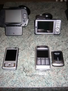
I recently gave the SE P910i's Bluetooth GPS receiver to a friend in the Philippines. He has an XDA IIs PDA and after installing the MapKing software (with a Manila map), the receiver worked beautifully. All the usual features you'd find on a regular satnav is on the software ... and here's a sample screenshot, but with a different map:

The Manila map's detail is down to street-level, but my friend claims a number of small streets are missing.
-
Tsikot Member
- Join Date
- Oct 2007
- Posts
- 2
October 19th, 2007 09:41 AM #95yup , it's compatible with most Garmin products like Nuvi and StreetPilot. If you have Mapsource, just download the installer , run it on Windows XP, and it should automatically install Philippine Routable as a map option on Mapsource. Be careful not to overwrite maps existing on your SD card. Suggest you use a new one.
if you don't have Mapsource, you'll have to use a program like SendMap20 (also availabel for free) from internet and convert the .img file to GMAPSupp.img which you can copy to SD card GARMIN directory. Suggest you use a new SD card so as not to overwrite other maps you have on old SD card.
-
Tsikot Member Rank 3
- Join Date
- Sep 2005
- Posts
- 1,218
October 19th, 2007 12:43 PM #96Thanks again. If I get the chance I'll borrow a friend's Nuvi, and try your map before getting one. Cheers!
-
 so many rides,so lil $$$
- Join Date
- Oct 2002
- Posts
- 1,496
October 19th, 2007 06:28 PM #97so i can buy any GPS unit from abroad and download these maps so that theyll work here in the phils? Originally Posted by Carlos H. Lopez
-
Verified Tsikot Member
- Join Date
- Oct 2004
- Posts
- 64
January 12th, 2008 05:53 PM #98Sorry for resurrecting a thread back from the dead but I'd like to report that I got my Nuvi 650 today.....loaded up the Philippine maps and everything works!!
What a hoot!!
-
so many rides,so lil $$$
- Join Date
- Oct 2002
- Posts
- 1,496
January 13th, 2008 01:02 AM #99just the answer ive been looking for!!!
dude where did you get the maps? :D
-
 Roadie
- Join Date
- Aug 2007
- Posts
- 820
January 13th, 2008 04:02 AM #100How much for the Nuvi 650? is it avail locally? Where to get the map? Originally Posted by afterglow


 Reply With Quote