
RPLB 220100Z 26012KT 6000 -RA SCT018 OVC080 26/23 Q0998 A2947 LGT RA CONTUS
RPLB 220000Z 32009KT 8000 FEW018 OVC080 29/25 Q0997 LGT SHRA
RPLB 212300Z 34014KT 9000 FEW018 OVC080 28/23 Q0997 LGT SHRA
RPLB 212200Z 02004KT 5000 FEW018 OVC080 26/22 Q0997 LGT SHRA
RPLB 212100Z 02010G20KT 9000 SHRA FEW018 OVC080 25/22 Q0998 LGT RASH
RPLB NIL
These are Olongapo's most current weather observations. 0100z/09 am shows the wind direction have shifted and is now westerly. It certainly looks like "Frank" is passing by. I did notice the low wind speeds.
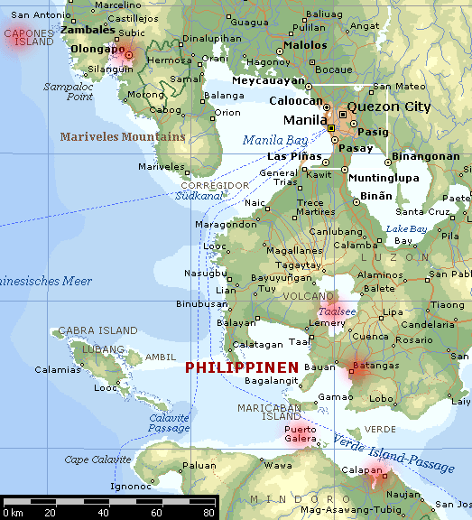
Are there mountains to the east of Olongapo? If there are that's probably why the wind speeds are low. The mountains are blocking the low level flow. I still wouldn't fly around in an airplane or something. The wind shear above would tear it apart.
The winds should pick up once or if the wind direction shifts to the same orientation as the mountains (north to south, east to west, etc). Or maybe not at all if the center's too far away by then.
The Largest Car Forum in the Philippines
- Forums
- Discussions
- Events
- Community
Results 41 to 60 of 67
-

 Tsikoteer

- Join Date
- Jan 2006
- Posts
- 12,398
June 22nd, 2008 09:48 AM #41Last edited by Jun aka Pekto; June 22nd, 2008 at 09:53 AM.
-
 I'm always around
- Join Date
- May 2005
- Posts
- 4,819
June 22nd, 2008 09:53 AM #42simula na ng heavy rains and wind dito sa tarlac....going on for more than 2 hours na.
-
 Social Dementia
- Join Date
- Sep 2003
- Posts
- 25,189
June 22nd, 2008 10:13 AM #43http://www.gmanews.tv/story/102578/T...its-many-areasTyphoon 'Frank' whips Metro; power outage hits many areas
MANILA, Philippines - Typhoon Frank (Fengshen) has entered Metro Manila Sunday morning under Public Storm Signal Number 3 with strong winds whipping electric wires and trees, and brownouts hitting several areas including Fairview, Caloocan, Novaliches, Parañaque, Pasay, and Muntinlupa.
Rene Famil of the Philippine Atmospheric Geophysical and Astronomical Services Administration told radio dzBB that "Frank" had started entering the metropolis at about 5 a.m., with the eye of the storm seen at the vicinity of Tayabas, in Quezon province, 60 kilometers southeast of Metro Manila.
Frank" packed maximum sustained winds of 120 kilometers per hour (kph) near the center and gustiness of up to 150 kph, and was moving north-northwest at 15 kph.
By Monday morning it is expected to be 70 kilometers (km) northwest of Baguio City. By Tuesday morning it is expected to be 260 km West southwest of Basco, Batanes.
By Wednesday morning it is expected to be 330 km northwest of Basco, Batanes.
Storm Signal No. 3 are also up in Oriental Mindoro, Occidental Mindoro, Lubang Island, Marinduque, Batangas, Laguna, Cavite, Rizal, Quezon province, Polilio Island, Southern Aurora, Nueva Ecija, Bulacan, Pampanga, Tarlac, Pangasinan, Zambales and Bataan.
Under Signal No. 2 are the Calamian Group of Islands, Romblon, Camarines Norte, rest of Aurora, Quirino, Nueva Vizcaya, Benguet, and La Union.
Under Signal No. 1 are Northern Palawan, Burias Island, Albay, Camarines Sur, Southern Isabela, Ifugao, Mountain Province, Ilocos Sur, Aklan, Capiz, and Antique. - GMANews.TV
-
Social Dementia
- Join Date
- Sep 2003
- Posts
- 25,189
June 22nd, 2008 10:16 AM #44This looks bad. Same company that brought us the Dona Paz disaster...
http://www.gmanews.tv/story/102587/C...n-had-capsizedCoast Guard verifies report that ship off Sibuyan had capsized
MANILA, Philippines - The Philippine Coast Guard (PCG) is verifying reports that the ferry, which ran aground off Sibuyan Island in Romblon province, has already capsized.
Vice Admiral Wilfredo Tamayo, commandant of the PCG, told radio dzBB on Sunday that a rescue ship was sent to the area to check on MV Princess of Stars that carried 702 passengers and 121 crew members.
He said the PCG received reports that the local populace saw a "silhouette of a capsized ship."
"Ito ay iba-validate pa natin kasi alam naman natin na maraming nai-uulat na maritime incidents. Hindi tayo nakakatiyak kung 'yon bang tinutukoy nila ang ating hinahanap. (We will validate the information in the midst of various reports we receive about maritime incidents. We are not yet sure if the ship they are talking about is the same ship we are looking for)," he said.
Tamayo said he expected the PCG's rescue ship to reach the area within two to three hours.
The ship owned by Sulpicio Lines that was bound for Cebu left Manila on Friday, at 8 p.m.
In an interview with a radio station on Sunday, Nanette Tansingco, mayor of San Fernando town in Romblon, said that she received reports from a police and Bantay Dagat team that the ship had sunk off the island of Sibuyan. She said the team saw four dead bodies. - GMANews.TV
-
Tsikoteer
- Join Date
- Jan 2006
- Posts
- 12,398
June 22nd, 2008 10:18 AM #45The 10 am obs from Olongapo:
RPLB 220200Z 31017KT 5000 -RA SCT018 OVC080 26/22 Q0998 A2947 LGT RA CONTUS
The wind direction shifted back northwesterly. I decided to look at a map of the place. Sure enough, there's mountains (oriented N-S) not just east of Olongapo but west as well. That's why the previous hour's winds were low.
It'll take a wind shift coming either from the south or from the north for the wind speeds to pick up. There's also bound to be a funneling effect between the mountains to the west and to the east.
From storyal.de
Last edited by Jun aka Pekto; June 22nd, 2008 at 10:20 AM.
-
Tsikoteer
- Join Date
- Jan 2006
- Posts
- 12,398
-
 Tsikot Member Rank 4
- Join Date
- Sep 2006
- Posts
- 4,488
June 22nd, 2008 10:48 AM #47Tumigil na rin ang malakas na hangin dito, malakas na ulan naman ang kapalit!
Last edited by Zeus; June 22nd, 2008 at 10:56 AM.
-
Tsikot Member Rank 4
- Join Date
- Sep 2006
- Posts
- 4,488
June 22nd, 2008 10:55 AM #48Bakit kaya pinayagan umalis yan, e nakita na nga papunta sa mindoro area yun bagyo kahapon e. ayon sa news, nag horn distress signal daw kagabi noong bandang hating gabi tapos biglang tumahimik. Mukhang na sa loob yata halos lahat ng pasahero at crew noong tumaob na ala palabas na 'Poseidon' Originally Posted by Monseratto


Last edited by Zeus; June 22nd, 2008 at 11:12 AM.
-
Tsikot Member Rank 4
- Join Date
- Sep 2006
- Posts
- 4,488
June 22nd, 2008 11:03 AM #49Areas in some portion of M.Manila are now flooded, and according to report a while ago, portions in front of Manila City hall is knee deep. So stay home if possible
Metro Manila submerged in floodwaters
[SIZE=2]Floodwaters brought by Typhoon Frank (international codename Fengshen) submerged some areas in Metro Manila early Sunday, dzMM Special Coverage reporters said.[/SIZE]
[SIZE=2]The Metropolitan Manila Development Authority (MMDA) said gutter-deep floodwaters submerged Pasay-Rotonda and Tramo Street in Pasay City and Alabang Viaduct in Muntinlupa City. [/SIZE]
[SIZE=2]MMDA said knee-deep water also flooded Ramon Magsaysay Boulevard near Pureza Street in Manila. [/SIZE]
[SIZE=2]Acacia Lane in Shaw Boulevard, Mandaluyong City and Nichols and Service Road in Parañaque City are impassable to light vehicles. [/SIZE]
[SIZE=2]Strong winds also toppled electricity post with two transformers near Wack-Wack along Shaw Boulevard but no one was reported hurt. [/SIZE]
[SIZE=2]Both Bagong Barrio in Caloocan City and Gate 4 in front of Camp Aguinaldo in Quezon City have been submerged in gutter-deep floodwaters while knee-deep water hit most parts of Malabon City. [/SIZE]
[SIZE=2]Malabon officials said some of the city’s streets are no longer passable to light vehicles. [/SIZE]
[SIZE=2]MMDA officials said the creek on Araneta Avenue in Quezon City has overflowed, flooding Maria Clara Street. [/SIZE]
[SIZE=2]Meanwhile, all domestic flights have been cancelled while international flights have been delayed as Frank battered the country. Reports from Zeny Silva and dzMM regions[/SIZE]
Source: www.abs-cbnnews.com
June 22, 2008Last edited by Zeus; June 22nd, 2008 at 11:35 AM.
-
 Driver
- Join Date
- Oct 2002
- Posts
- 4,456
June 22nd, 2008 11:09 AM #50Mukhang pangasinan nanaman and up north ang tama nito. Hindi pa nga fully recovered yung mga victims dun. Tsk
-
 Tsikot Member Rank 8
- Join Date
- Oct 2002
- Posts
- 21,433
-
Tsikot Member Rank 8
- Join Date
- Oct 2002
- Posts
- 21,433
June 22nd, 2008 11:43 AM #52Bakit parang dito sa forecast na ito, palabas na ng lupa by 12noon today ang bagyo?

-
Tsikot Member Rank 4
- Join Date
- Sep 2006
- Posts
- 4,488
June 22nd, 2008 11:47 AM #53Paiba-iba kasi ang direksyon ng bagyo e, na sa clark area at nandyan na yata sa inyo yung bagyo ayon sa pagasa. Originally Posted by boybi
-
Tsikoteer
- Join Date
- Jan 2006
- Posts
- 12,398
June 22nd, 2008 11:50 AM #54What do you mean 12 noon? 12 noon in Manila is 4 o'clock zulu/GMT/UTC. If you mean 22/12Z, that's 8 o'clock pm local time over there. Originally Posted by boybi
To convert zulu time to local time in the Philippines, you need to add 8 hours to zulu time.Last edited by Jun aka Pekto; June 22nd, 2008 at 11:59 AM.
-
 one shot
- Join Date
- May 2007
- Posts
- 2,328
June 22nd, 2008 12:05 PM #55Ang weather naman ngayon dito ay umabot na naman ng tripple digits sobrang init, patay na naman kami sa kuryente nito.
104 deg./ 40.0 C
-
Tsikot Member Rank 4
- Join Date
- Sep 2006
- Posts
- 4,488
June 22nd, 2008 12:06 PM #56Na sa teleconference ngayon si president Arroyo at naiinis sa vice admiral ng coast guard o navy at nagtatanong bakit pinayagan umalis at hindi nag bigay ng warning sa barko. Originally Posted by Monseratto
-
Tsikoteer
- Join Date
- Jan 2006
- Posts
- 12,398
June 22nd, 2008 12:43 PM #57RPLB 220410Z 22022G39KT 2000 +RA BKN015 OVC080 25/24 Q0997 A2944 HVY RA CONTUS
RPLB 220332Z 22020KT 5000 +RA SCT018 OVC080 26/24 Q0998 HVY RA CONTUS
RPLB 220300Z 20008KT 150V240 5000 -RA FEW015 SCT018 OVC080 26/23 Q0998 A2947 LGT RA CONTUS
RPLB 220200Z 31017KT 5000 -RA SCT018 OVC080 26/22 Q0998 A2947 LGT RA CONTUS
RPLB 220100Z 26012KT 6000 -RA SCT018 OVC080 26/23 Q0998 A2947 LGT RA CONTUS
The winds have started to pick up at Olongapo after the wind direction shifted southwesterly. Looking at the map, the city is wide open from that direction. There's also the mountains to the east providing orographic lift, enhancing the already heavy rain. I'd be extra careful if I live at the slopes because of the possibility of mudslides and overflowing streams. All that water running down the slopes of the mountains have to go somewhere.
-
 BANNED BANNED BANNED
- Join Date
- Sep 2005
- Posts
- 3,829
June 22nd, 2008 12:48 PM #58Dapat makulong yang mga yan, napaka bobo naman. Originally Posted by Zeus

-
Social Dementia
- Join Date
- Sep 2003
- Posts
- 25,189
June 22nd, 2008 01:12 PM #59Sulpiclo lines is mum on the subject. Umpisahan na yung fingerpointing, they say the coastguard didn't advise them not to sail. Originally Posted by CoDer
-
Tsikoteer
- Join Date
- Jan 2006
- Posts
- 12,398
June 22nd, 2008 01:22 PM #60The 05z/1pm (or 1300L in 24-hr clock) observations:
RPLB 220500Z 23039G51KT 1000 BKN015 OVC080 26/25 Q0996 A2941 HVY RA CONTUS
RPLC 220500Z 21016KT 170V240 2900 SCT008 BKN012 OVC066 VV006 25/23 Q0995 A2939 NOSIG RMK LGT RA CONTUS
RPLI 220500Z 04010KT 9999 FEW020 SCT100 37/23 Q995 NOSIG
RPLL 220500Z 18010KT 4000 -RA SCT020 OVC080 24/24 Q1000 CONTUS LGT RA RMK A2954
It looks like Manila (RPLL) will be settling down to just rain. Olongapo's (RPLB) now gusting to 51kt or 93kph. Visibility is 1km. It's much worse than Manila's lowest visibility of 2km earlier. So, that orographic lift may be playing a part in the stronger rain.
Clark/Angeles (RPLC) is a bit puzzling. The observation has VV006. That means the observer can't tell where the sky ends or begins and he can see up only 600 ft. Yet, he's also carrying other cloud layers. It's either one or the other. So, there's a typo in the observation. I can safely guess the poor observer is stressing out trying to keep up with the changing weather plus taking care of phone calls, briefings, etc. I've been there. So, oh well. He He. I still like to keep a semblance of quality control, though.
Last edited by Jun aka Pekto; June 22nd, 2008 at 01:28 PM.

 Reply With Quote