
Originally Posted by EQAddict
 Go North, Kid !!!
"The measure of a man is what he does with power" LJIOHF!
27.9K _/_/_/_/_/:matrix:_/_/_/_/_/
The Largest Car Forum in the Philippines
- Forums
- Discussions
- Events
- Community
Results 5,341 to 5,360 of 11644
-

 Hoosier'ed Hotspur

- Join Date
- Dec 2005
- Posts
- 39,174
October 16th, 2015 01:05 PM #5341
-
 Social Dementia
- Join Date
- Sep 2003
- Posts
- 25,189
October 16th, 2015 01:25 PM #5342Wondering why the forecast show the storm strength won't be affected too much by the Sierra Madre mountain ranges and why it will take the storm 3 days to cross Luzon... that's what people are worried about. Only good thing is it will pass over the water sheds that need the rain. Originally Posted by Jun aka Pekto
Last edited by Monseratto; October 16th, 2015 at 01:33 PM.
-
Social Dementia
- Join Date
- Sep 2003
- Posts
- 25,189
October 16th, 2015 01:25 PM #5343+++++++++++++++++++++++++++++
Last edited by Monseratto; October 16th, 2015 at 01:33 PM.
-
BANNED BANNED BANNED
- Join Date
- Sep 2014
- Posts
- 8,492
-
Tsikoteer
- Join Date
- Aug 2003
- Posts
- 9,720
October 16th, 2015 01:33 PM #5345i read a tweet that Lando is bring several feet of rain. Are we talking about Ondoy-level rains here?
-
BANNED BANNED BANNED
- Join Date
- Sep 2014
- Posts
- 8,492
October 16th, 2015 01:38 PM #5346Malang Ondoy level kase hindi naman gano umulan since June. Nature has to correct the imbalance
-
 Tsikoteer
- Join Date
- Jan 2006
- Posts
- 12,398
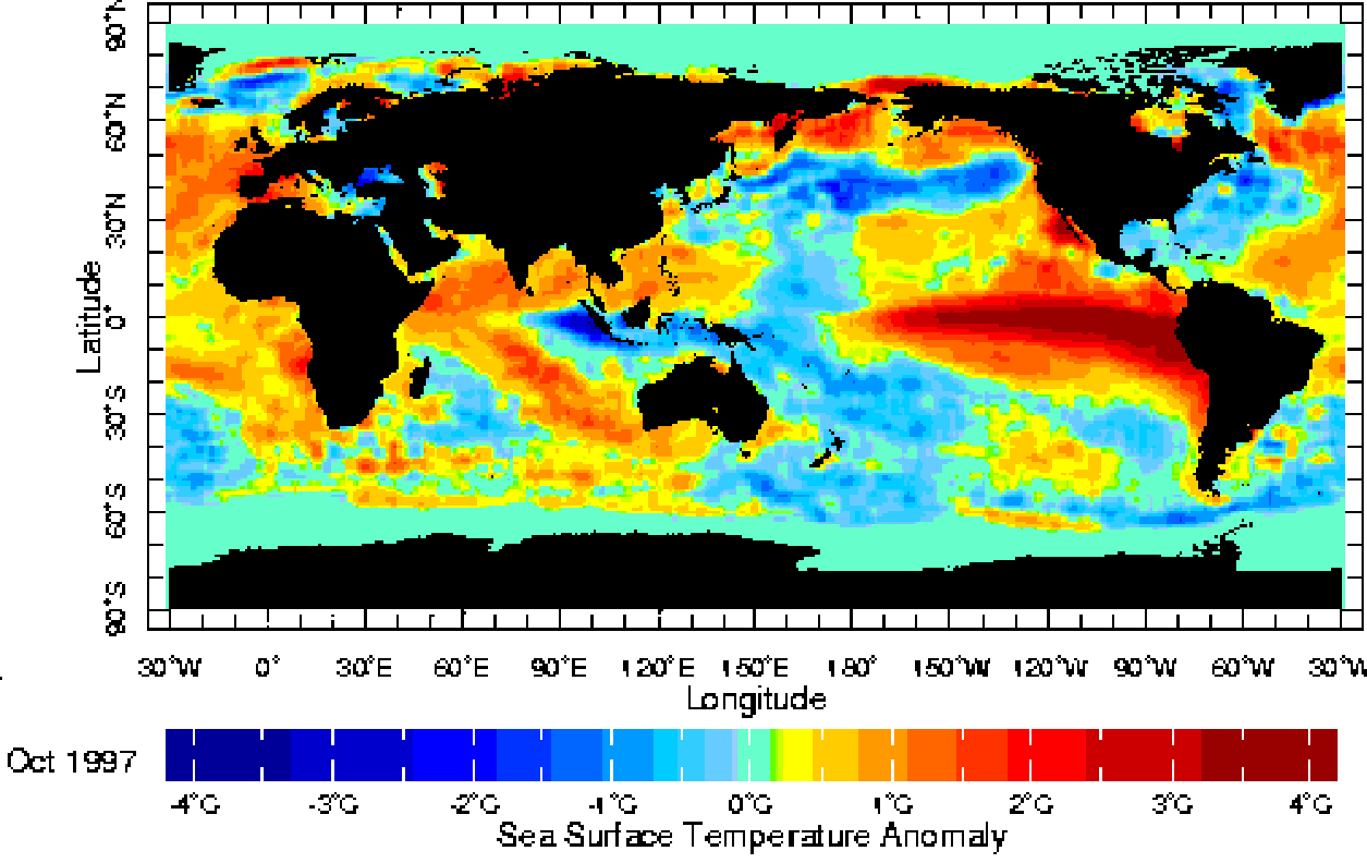
October 16th, 2015 04:04 PM #5347El Nino year? Stronger, warmer current right where typhoon development occurs and warm water is what fuels typhoons. Originally Posted by Hanren
2015-2016 is expected to be an El Nino year. Sample:
-
BANNED BANNED BANNED
- Join Date
- Jan 2015
- Posts
- 4,580
October 16th, 2015 04:10 PM #5348el niño brings drought, right? i always wonder why they call it at that when catholics believe the sto. niño bring them good tidings. Originally Posted by Jun aka Pekto
-
Tsikoteer
- Join Date
- Jan 2006
- Posts
- 12,398
October 16th, 2015 04:30 PM #5349El Nino is a warm(er) water current. Typhoon development normally start off the coastal waters of western South America in the same way hurricane development start off the west coast of Africa. Look where that El Nino current is located. Right smack where typhoons first start to develop. Originally Posted by Juan Martinez
Droughts? That is normally caused by something else.
Edit:
The tropical systems start out as tropical waves. Depending on atmospheric conditions very high up, there may be a Tropical Upper Tropospheric Trough (TUTT) present above the path the tropical waves take. If a tropical wave passes underneath a TUTT, there's a good chance the tropical wave will intensify into a depression/storm/typhoon. With an El Nino year, there is normally an increase in the formation of tropical waves.Last edited by Jun aka Pekto; October 16th, 2015 at 05:10 PM.
-
 Running on Empty...
- Join Date
- Oct 2002
- Posts
- 17,338
October 16th, 2015 06:31 PM #5350Weather on the east is more harsh. Accessibility is harder too as you have to cut through the Sierra Madres. Originally Posted by Jun aka Pekto
-
 Tsikoteer
- Join Date
- Nov 2009
- Posts
- 12,364
October 16th, 2015 06:41 PM #5351How about us peeps in the metro?
Ramdam ba natin ito?
Sent from my iPhone using Tapatalk
-
BANNED BANNED BANNED
- Join Date
- Jan 2015
- Posts
- 4,580
October 16th, 2015 09:44 PM #5352
-
Verified Tsikot Member
- Join Date
- Oct 2006
- Posts
- 6,507
October 16th, 2015 10:10 PM #5353Ang lakas at ang lamig ng hangin dito sa Legaspi. Yung ulan paaambon-ambon lang pero kanina pa umaga di tumitigil.
-
Social Dementia
- Join Date
- Sep 2003
- Posts
- 25,189
October 16th, 2015 10:11 PM #5354We might see Ondoy type of rains... At least the goverment is taking it seriously...
-
 Tsikot Member Rank 3
- Join Date
- Oct 2006
- Posts
- 2,380
-
BANNED BANNED BANNED
- Join Date
- Jan 2015
- Posts
- 4,580
October 17th, 2015 01:32 AM #5356Executive Order No. 66, Series of 2012:
EXECUTIVE ORDER NO. 66
PRESCRIBING RULES ON THE CANCELLATION OR SUSPENSION OF CLASSES AND WORK IN GOVERNMENT OFFICES DUE TO TYPHOONS, FLOODING, OTHER WEATHER DISTURBANCES, AND CALAMITIES
WHEREAS, x x x
Section 1. Automatic Cancellation or Suspension of Classes and Work in Government Offices, The following guidelines shall be followed for the automatic cancellation or suspension of classes in all public and private elementary, secondary and tertiary schools, as well as work in all government offices:
a. When Signal No. 1 is raised by PAGASA, classes at the pre-school level, in the affected area, shall be automatically cancelled or suspended.
b. When Signal No. 2 is raised by PAGASA, classes at the pre-school, elementary and secondary levels, in the affected area, shall be automatically cancelled or suspended,
c. When Signal No. 3 or higher is raised by PAGASA, classes at pre-school, elementary, secondary, and tertiary levels, in the affected area, including graduate school, as well as work in all government offices, shall be automatically cancelled or suspended.
The PAGASA shall issue weather forecasts through various media outlets (radio and television), and the NDRRMC, not later than 10:00 PM of the previous day and 4:30 AM of the day of the intended cancellation of classes and work. In cases where there are classes and work in the morning and suspension of classes and work is only effective in the afternoon, PAGASA should issue the forecast not later than 11:00 AM of the said day.
Section 2. Localized Cancellation or Suspension of Classes and Work in Government Offices. In the absence of typhoon signal warnings from PAGASA, localized cancellation or suspension of classes and work in government offices may be implemented by local chief executives, as chairmen of the Local Disaster Risk Reduction and Management Council (LDRRMC) concerned, in coordination with PAGASA and the NDRRMC, specifically in flood-prone or high risk areas.
Announcements will be made not later than 4:30 AM of the day of the intended cancellation of classes and work, or not later than 11:00 AM for suspension of work and classes in the afternoon session, through diverse mass media, particularly radio and television, landline communications and other technologies for communication within the community or locality.
Section 3. Cancellation or Suspension of Classes and Work in the Government During Other Calamities. Classes in all levels in both public and private schools as well as work in the government offices may be cancelled or suspended in areas affected by disasters or calamities other than typhoons, such as but not limited to floods, earthquakes, tsunami and conflagration, upon the declaration by the President of a State of Calamity based on the recommendation of the NDRRMC.
The concerned Local Disaster Risk Reduction and Management Office (LDRRMO) headed by the local chief executive shall be responsible for announcing the suspension of classes and work in the government offices in the affected areas in coordination with the NDRRMC, through all forms of mass media available under the circumstances.
Section 4. Maintenance of Work Force. In the event of cancellation or suspension of work in government offices due to any of the foregoing circumstances, the following government agencies, particularly those directly involved in disaster risk reduction and management, shall maintain the operations of their respective offices to ensure the continuity of the delivery of services to the public:
a. Office of the Executive Secretary
b. Department of National Defense
c. Department of the Interior and Local Government
d. Department of Social Welfare and Development
e. Department of Science and Technology
f. Department of Health
g. Department of Public Works and Highways
h. Department of Education
i. Other agencies whose operations the President or the NDRRMC may deem necessary.
The Heads of Offices of the foregoing agencies shall determine which of their respective divisions or units, particularly those related to disaster risk reduction and management, shall maintain its operations.
Section 5. Report to the President. The NDRRMC chaired by the Secretary of National Defense shall immediately inform the Office of the President, through the Executive Secretary, of the cancellation or suspension of classes and work in government offices in the affected areas.
Section 6. Concurrent Authority. The Office of the President, through the Executive Secretary, shall have concurrent authority with the NDRRMC to cancel or suspend classes and work in government offices in the affected areas.
Section 7. Repeal. All issuances, orders, rules and regulations or parts thereof, inconsistent with this Executive Order are hereby repealed, amended or modified accordingly.
Section 8. Effectivity. This Executive Order shall take effect immediately.
DONE, in the City of Manila, this 9th day of January in the year of our Lord, Two Thousand and Twelve
(Sgd.) BENIGNO S. AQUINO III
By the President:
(Sgd.) PAQUITO N. OCHOA, JR.
Executive Secretary
-
Tsikoteer
- Join Date
- Jan 2006
- Posts
- 12,398
October 17th, 2015 02:04 AM #5357All that beautiful pristine land and the Metro is packed liked sardines. Originally Posted by vinj

-
Hoosier'ed Hotspur
- Join Date
- Dec 2005
- Posts
- 39,174
-
Social Dementia
- Join Date
- Sep 2003
- Posts
- 25,189
October 17th, 2015 09:49 AM #5359
Typhoon Lando to make landfall over Aurora-Isabela area between Saturday night & Sunday morning
Signal #1: Metro Manila, Pangasinan, Bulacan, Pampanga, Tarlac, Zambales, Bataan, Rizal, Batangas, Laguna, southern Quezon, Cavite, Albay, Camarines Norte, Camarines Sur, Catanduanes, Batanes
Signal #2: northern Quezon, Nueva Vizcaya, Nueva Ecija, La Union, Benguet, Ifugao, Mt. Province, Ilocos Sur, Ilocos Norte, Abra, Apayao, Kalinga, Cagayan including Babuyan & Calayan Group of Islands
Signal #3: Aurora, Quirino, Isabela, Polillo Island
-
 Tsikot Member Rank 5
- Join Date
- Sep 2003
- Posts
- 21,384
October 18th, 2015 04:13 AM #5360Anak ng......lakas ng hangin ah.
Its 3:13am. Nagising ako.....
Anong signal na ba? Sablay na naman ata Pagasa.


 Reply With Quote