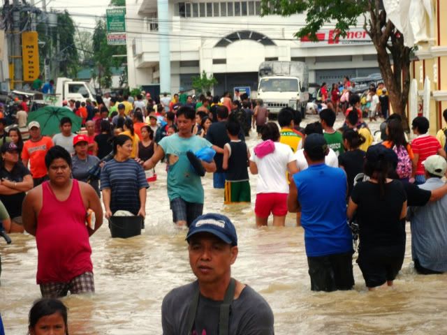
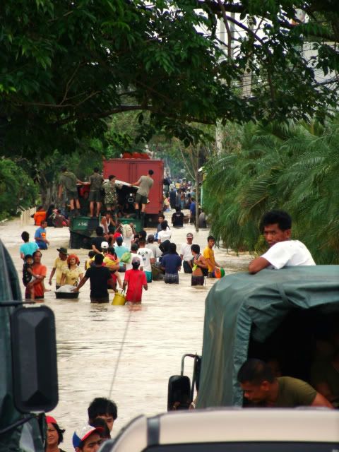
ingat sa baha........

The Largest Car Forum in the Philippines
- Forums
- Discussions
- Events
- Community
Results 581 to 600 of 11634
-

 Tsikot Member Rank 5

- Join Date
- Sep 2003
- Posts
- 21,384
-
 Tsikoteer
- Join Date
- Sep 2009
- Posts
- 4,600
October 1st, 2011 10:25 PM #582wow! ang sarap naman nyan! may sumiwang na itim ah? Originally Posted by chua_riwap

sa china siguro ito?
-
Tsikot Member Rank 5
- Join Date
- Sep 2003
- Posts
- 21,384
October 2nd, 2011 12:06 AM #583may panty liner ba o pasador? Originally Posted by holdencaulfield

sa china nga siguro yan.....
-
Tsikoteer
- Join Date
- Sep 2009
- Posts
- 4,600
October 2nd, 2011 01:15 AM #584panty liner ba yan? pero tumambok ano, sa may baba nakasipsip ng tubig baha. pero sarap parin nyan, walang pasa-pasador sakin! Originally Posted by chua_riwap
hehe- pina sasaya lang kita brochua, di ka man naka-ani ngayon, 3x ma-aani mo sa susunod! dasal dasal lang!
-
Tsikot Member Rank 5
- Join Date
- Sep 2003
- Posts
- 21,384
October 2nd, 2011 01:22 AM #585^ ang masaklap....meron na namang LPA. pag di raw nagbago ng behavior, this would turn into a storm and could enter the PAR by monday.
GOD bless the Phl......:pope:
-
 Moderator
- Join Date
- Nov 2010
- Posts
- 25,276
October 2nd, 2011 01:24 PM #586^ Sana nga mag-iba ng direksyon!
Fasten your seatbelt! Or else... Driven To Thrill!
-
Tsikot Member Rank 5
- Join Date
- Sep 2003
- Posts
- 21,384
October 2nd, 2011 06:13 PM #587eto na......

same path daw.
PAGASA: New LPA may become new cyclone by Wednesday - Nation - GMA News Online - Latest Philippine News
PAGASA: New LPA may become new cyclone by Wednesday
10/02/2011 | 03:46 PM
A low-pressure area east of Luzon may develop into a tropical cyclone by Wednesday, the Philippine Atmospheric Geophysical and Astronomical Services Administration said Sunday.
PAGASA acting administrator Nathaniel Servando said the LPA will be codenamed "Ramon," should it become a tropical depression.
"The LPA east of Luzon, our prediction shows by Wednesday it will develop into a tropical depression to be called 'Ramon,'" Servando said at a meeting of the National Disaster Risk Reduction and Management Council Sunday afternoon.
President Benigno Aquino III personally attended the NDRRMC meeting.
Several parts of Luzon are still reeling from the effects of typhoons "Pedring" (Nesat) and "Quiel" (Nalgae). More than 50 people had been killed while several areas in Bulacan and Pampanga were flooded in the wake of the two cyclones.
On Saturday, Department of Science and Technology Undersecretary Graciano Yumul Jr. said the incoming cyclone may target northern Luzon, the same area battered by the previous two cyclones.
"Ang malungkot Northern Luzon uli ang tinatahak (What is sad is that it is heading for Northern Luzon)," Yumul said in an interview on dzBB radio Saturday. — KBK, GMA News
-
Tsikot Member Rank 4
- Join Date
- Oct 2002
- Posts
- 2,719
October 3rd, 2011 07:12 PM #588it was sunny this afternoon in calasiao (pangasinan) yet water is still up to almost the door sill

and water current was fairly strong sideways

fervently prayed i won't be mr. lao part 2
-
Tsikot Member Rank 5
- Join Date
- Sep 2003
- Posts
- 21,384
-
Tsikot Member Rank 4
- Join Date
- Oct 2002
- Posts
- 2,719
October 4th, 2011 09:34 AM #590err ... yah, i was informed Originally Posted by chua_riwap
but fording a total 5km of floods (in calasiao and dagupan) wasn't fun anymore
-
Moderator
- Join Date
- Nov 2010
- Posts
- 25,276
October 4th, 2011 09:55 AM #591Grabe ang layo niyang fording mo! Originally Posted by kinyo
Fasten your seatbelt! Or else... Driven To Thrill!
-
Tsikot Member Rank 4
- Join Date
- Jan 2003
- Posts
- 2,979
-
Tsikot Member Rank 4
- Join Date
- Jan 2003
- Posts
- 2,979
October 4th, 2011 03:10 PM #593
only means of transpo.... or walk at least 15 kms of waist deep waters....

Jollibee!
-
 Social Dementia
- Join Date
- Sep 2003
- Posts
- 25,189
October 4th, 2011 03:58 PM #594Proof the Philippines is slowly sinking... expect an upsurge in skin diseases.
-
Tsikot Member Rank 5
- Join Date
- Sep 2003
- Posts
- 21,384
-
Social Dementia
- Join Date
- Sep 2003
- Posts
- 25,189
October 10th, 2011 11:20 AM #596Here comes another one. Maghanda na kayo.

Strong LPA (92W/1007 MB) has accelerated Westward during the past 12 hours and will likely develop into a TD later today...threatens NE Mindanao-Visayas Area. Its center was located about 792 km ESE of Surigao City (8.1N 132.5E)...max winds of 35-55 kph...moving WNW * 19 kph towards Surigao-Leyte Area.
-
Tsikot Member Rank 5
- Join Date
- Sep 2003
- Posts
- 21,384
-
Social Dementia
- Join Date
- Sep 2003
- Posts
- 25,189
-
 Running on Empty...
- Join Date
- Oct 2002
- Posts
- 17,338
-
 Hoosier'ed Hotspur
- Join Date
- Dec 2005
- Posts
- 39,174
October 10th, 2011 11:30 PM #600
It is projected to travel in the North-West direction, so no high pressure area in the north.
Was the typhoon formed near the Philippines?
Or, was it, that during the first phases of the typhoon, it was affected by the high pressure area from the North (cold front) which caused it to travel westward for a while, instead of the usual NorthWestward direction....
14.2K:juggle:

 Reply With Quote