
bka interested lang kyo...
this is kewl...may sattelite map option..u can see the actual place...amazing!!! (babaw ko kc eh hehehe).
http://maps.google.com/
The Largest Car Forum in the Philippines
- Forums
- Discussions
- Events
- Community
Results 1 to 18 of 18
-
 Verified Tsikot Member

- Join Date
- Oct 2004
- Posts
- 139
April 6th, 2005 05:29 PM #1
-
FrankDrebin Guest
-
 Chanis Stayl!!
- Join Date
- Dec 2003
- Posts
- 11,316
-
Tsikot Member Rank 3
- Join Date
- Nov 2002
- Posts
- 1,773
April 6th, 2005 05:56 PM #4di pa. north america pa lang. although these images are 6-12 months old. also, kung mapapansin mo, blurred yung areas kung saan may vital installations (ie. white house, pentagon, etc.). pero i was hoping na makikita mo yung mga babae sa beaches. hehehe. di pala ganun ka-taas ang zoom level hehehhe
-
 Tsikoteer
- Join Date
- Aug 2003
- Posts
- 3,273
April 6th, 2005 06:16 PM #5north america lang pare.
pero galing nung map. parang map-quest.com.
sana may ganito din dito sa atin.
-
FrankDrebin GuestApril 6th, 2005 06:26 PM #6
Sayang. Titingnan ko pa naman kung malala na yung kalawang ng bubong ng bahay namin. :D
-
 Tsikot Member Rank 4
- Join Date
- Sep 2004
- Posts
- 4,933
April 6th, 2005 06:39 PM #7galing..saw where i grew up and my college before...I hope there would be one for the Philippines or other countries
-
 Verified Tsikot Member
- Join Date
- Sep 2004
- Posts
- 258
April 6th, 2005 07:15 PM #8Actually, meron dati. Isang project ng mga Lopez. Sa BenPress bldg dati ang office. Meron na ring mga areal photos ng Metro Manila. Kaso masyado yata magastos, hindi nakayanan, kaya medyo di nagtagal.
-
 Tsikot Member Rank 5
- Join Date
- Nov 2002
- Posts
- 6,753
-
 Vote For Pedro
- Join Date
- Feb 2004
- Posts
- 2,420
-
 one shot
- Join Date
- May 2007
- Posts
- 2,328
April 30th, 2008 03:21 AM #11Try google earth. Pati bahay namin sa probinsya nakikita ko ang maganda yong kalabaw na naka tali sa may punong kahoy. I dont know who owns it pero nakikita. I have this for 4 years now and my kids enjoying on it.
Last edited by v6dreamer; April 30th, 2008 at 03:29 AM.
-
Verified Tsikot Member
- Join Date
- May 2007
- Posts
- 236
April 30th, 2008 05:06 AM #12+1 kita ko din yung bubong ng bahay namin sa batangas. pero hindi pa uli updated kasi kung titingnan mo sa google earth eh hindi pa tapos yung STAR tollway.every ilang months kaya bago mag update ang google earth? Originally Posted by v6dreamer

-
Tsikot Member Rank 3
- Join Date
- Apr 2007
- Posts
- 1,076
April 30th, 2008 06:13 AM #13ina update naman nila eto i just dont know gaano katagal before they take pix again...kasi dati yung bahay namin sa rizal kita yung oto ng tatay ko naka park sa harap..tapos minsan nakita ko wala na yung oto..last na visit ko dalawang oto naka park...

malinaw na malinaw ang USA pati name ng streets and landmarks..kahit i zoom in mo malinaw pa rin..pero yung ibang parts like here sa pinas hazy na ang dating...but the thing is...yung mga known landmarks i-type mo lang sa search e dadalhin ka agad ng satellite dun.
-
Verified Tsikot Member
- Join Date
- Nov 2006
- Posts
- 263
April 30th, 2008 01:18 PM #14^^^only certain areas/cities/states are available right now but if you click on the tab marked "streets",all the streets that are marked blue means that you can actually click on it and itll show you the actual street picture and its sorrounding.
alot of streets in chicago are already getting the street view.
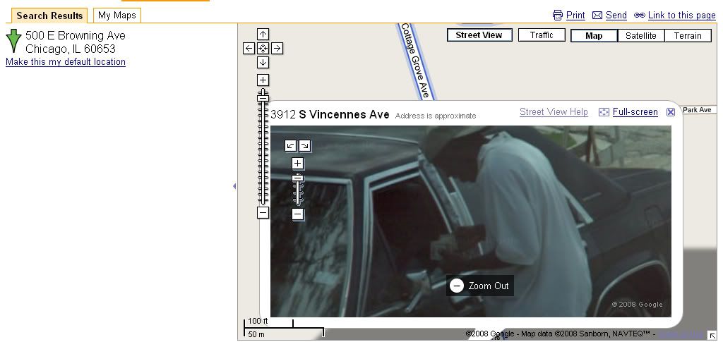
check out this drug deal going down caught while they were taking photos of the street of chicago..lol
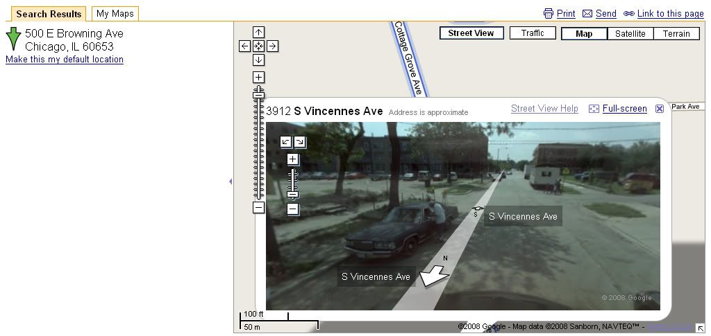
you can even zoom in on the picture and/or follow the streets
close up view of the drug deal...hahaha
-
 Tsikoteer
- Join Date
- Jan 2006
- Posts
- 12,398
April 30th, 2008 07:50 PM #15Oh, jeez. I hope you get caught, you bas***d.
Er, I mean the junkie. Sorry. I get carried away sometimes....
-
 Verified Tsikot Member
- Join Date
- Jul 2006
- Posts
- 186
May 1st, 2008 10:35 PM #16ever wondered na bakit wala kang nakikitang tao sa google earth (especially when you're viewing most parts in the Philippines)? karamihan makikita mo lang yung mga vehicles in the streets, pero yung naglalakad na tao sa kalye or mga rally...
hmm...
-
Tsikoteer
- Join Date
- Jan 2006
- Posts
- 12,398
May 2nd, 2008 04:47 PM #17Resolution. Either the lens resolution isn't high enough or only select images with the least people are being put online. Originally Posted by JagXtrm
Here, I noticed the images show it's mid-morning just before establishments open and just before recess in schools. But, I can make out a few people walking in the parking lot of the local Best Buy. Plus, looking at Sea World San Diego, I think I can see one of the Shamus.
Last edited by Jun aka Pekto; May 2nd, 2008 at 04:58 PM.
-
Tsikot Member
- Join Date
- Apr 2010
- Posts
- 1

 Reply With Quote